This system is not yet accessible on mobile.

GAIA operates through a full interactive interface designed for desktop environments.

To enter, switch device.

emissaryofgaia.com

© Emissary of GAIA B.V. All rights reserved.

status online
nodes13 / 18
envai18
humans2
About Whitepapers Pilots GAIA Botnet FAQ
Public-Service Use Cases

SignalSensor data, satellite feeds, weather stations
InterpretationAI contextualises and cross-references signals
ActionRecommended responses with traceable reasoning
ApprovalHuman sign-off before any action proceeds
CommsPublic alerts, briefings, multilingual translations
AuditFull decision trail logged for accountability

Water authorities, environmental agencies, and crisis coordinators face the same structural problem: the gap between detecting a signal and mounting an effective, coordinated response.

Emissary of GAIA closes that gap — a human-supervised decision-support layer connecting environmental monitoring to institutional action, approval, communication, and audit. Each stage supervised. Nothing automated past human authority.

Scroll
The Signal Chain

Five use cases. One decision framework.

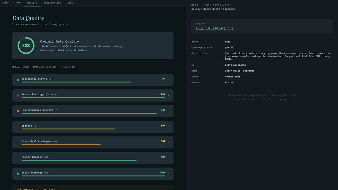
Emissary of GAIA maps every environmental use case to the same six-stage chain: from raw signal through interpretation, action, approval, communication, and audit.

Each stage is human-supervised. The system ingests environmental data, structures it into actionable intelligence, recommends response options with traceable reasoning, routes decisions for sign-off, and logs every step.

Nothing is automated past institutional authority. The matrix shows which stages are active per use case — click any row to explore.

5Use
Cases
Five public-service domains where environmental AI supports institutional decision-making.
2Pilot
Projects
Two use cases currently deployed with real institutions in live operational settings.
6Chain
Stages
Every use case follows the same six-stage chain: Signal, Interpretation, Action, Approval, Comms, Audit.
0Fully
Autonomous
No stage operates without human oversight. Every decision requires explicit sign-off.
Signal Chain Coverage by Use Case
Signal
Interpret
Action
Approval
Comms
Audit
Status
Flood Warning
Under Dev
Drought & Water Stress
Concept
Pollution Triage
Concept
River-Basin Coord.
Pilot
Public Consultation
Pilot
Click a row to explore →
In scope
Not yet scoped
What do these mean?
A lit node means this stage of the signal chain is designed or being developed for the use case — it does not mean operational. The status badge on the right shows actual project maturity. An unlit node means that stage is not yet part of the current scope for that use case.
Maturity Concept Prototype Under Dev Pilot Active
Use Case 01
Use Case 01
Water Management
Active

Flood Warning
And Citizen Communication

Operational ContextREF: GAIA-UC01-CTX

The institutional challenge is rarely a lack of data alone. More often, it is the gap between detection and coordinated response: the time required to interpret fragmented signals, prepare internal briefings, align across teams, and communicate clearly with residents before conditions worsen.

Emissary of GAIA helps public authorities interpret hydrological, meteorological, and geospatial signals in context. It generates reviewable priority actions, supports locality-specific warning preparation, and helps translate technical risk into public-facing communication.

View details
Flood warning
Under Development
Primary Users
Water authoritiesMunicipalitiesCrisis teamsCommunication officers
Improvements
Faster briefingsFaster warningsLocalised instructionsMultilingualTraceability

Event Dossier

Live
Latest 0 / 16
Example Scenario

A Flood Event on the Meuse

Water levels have been rising for two days.
The action threshold has been crossed.
Walk through the response chain, step by step.

Meuse River Basin Limburg, NL FEWS · KNMI · Gauge Network
Example Scenario

A Flood Event on the Meuse

Meuse River Basin Limburg, NL FEWS · KNMI · Gauge Network
0:00
T +0:00 Signal Aggregation
Water levels on the Meuse have been rising for two days. FEWS forecast models, real-time gauge readings, and KNMI precipitation data now converge: Meuse ENVAI flags an action threshold across the basin. Sustained rainfall upstream is confirmed.
T +0:18 Risk Interpretation
Meuse ENVAI cross-references water level projections with flood zone maps, population density, and critical infrastructure. Affected municipalities identified. Confidence intervals generated. Evacuation timing requirements calculated per zone.
T +0:32 Decision-Support Package
Meuse ENVAI drafts a reviewable package for the veiligheidsregio: risk summary, recommended GRIP escalation level, draft NL-Alert messages per municipality, evacuation route options, and resource deployment priorities. Every recommendation linked to its source evidence.
T +0:45 Policy Team Review
The veiligheidsregio policy team convenes — coordinating mayor, brandweer, politie, GHOR, and water board representatives. They review the package, adjust the warning level for two municipalities based on local knowledge, and approve GRIP-3 escalation. Every edit is logged.
Human-in-the-loop checkpoint
T +1:48 Communication
Two communication channels activate in parallel.
T +1:38 Emergency Services
Structured operational briefings dispatched to brandweer, politie, GHOR, and water board field teams via the regional coordination centre. Evacuation routes activated. Barrier deployment priorities confirmed. Each service receives role-specific information only.
T +2:10 Citizens
NL-Alert cell broadcast dispatched to affected zones. Localised, multilingual messages with neighbourhood-specific instructions — shelters, road closures, drinking water points. Citizens in immediate danger zones receive direct (video) calls from the Ecosystem Avatar, providing real-time spoken guidance in their own language.
T +2:12 Audit Trail
Full decision chain cryptographically sealed to a distributed ledger — every signal, model output, GRIP escalation record, policy team edit, coordination dispatch, and citizen communication hashed with timestamps and attribution. No participating agency can alter the record unilaterally. The institutional memory is immutable.
Use the button below each phase to advance to the next.
The Event Dossier on the right shows every artifact as it's generated by the Meuse ENVAI.
Response Chain Cryptographically Sealed
Under 3 Hours
Action threshold to citizen alert
Without Emissary of GAIA: 12–24 hours
The water hasn't reached the houses yet. The elderly couple and the pregnant woman in Valkenburg already received a spoken (video) call in their own language and received assisted evacuation. The evacuation route was cleared before the first road flooded.
6 phases completed
16 artifacts cryptographically sealed
fully human-supervised
Every recommendation traceable to source evidence
The policy team reviewed reasoning, not just conclusions. Each GRIP level, evacuation route, and NL-Alert draft linked back to the specific data that triggered it.
AI prepared — humans decided at every gate
The veiligheidsregio policy team took a full hour to convene, review, adjust two municipality warnings based on local knowledge, and formally approve. Every edit logged. The AI compressed preparation from hours to minutes — the human review took the time it deserved.
All services briefed simultaneously
This replaced the current serial cascade of phone calls and emails between coordination centres. Every service received their operational brief at the same moment.
Cryptographically sealed — no agency can alter the record
Every artifact hashed to a distributed ledger with timestamps and attribution. No single agency — veiligheidsregio, Rijkswaterstaat, or water board — can modify the record unilaterally. Post-event review uses immutable evidence, not individual recollections.
Use Case 02
Use Case 02
Water Stress
Active

Drought, Low-Water,
and Water Stress

Operational ContextREF: GAIA-UC02-CTX

Low-water conditions, prolonged drought, and broader water stress create pressure across ecology, navigation, infrastructure, and regional coordination.

Emissary of GAIA brings together water levels, weather patterns, ecological stress indicators, and contextual data to support earlier and more coherent responses.

View details
Drought and water stress
Concept
Primary Users
Water managersRegional authoritiesEnvironmental agencies
Improvements
Earlier detectionFaster advisoriesAgency consistencyTrade-off clarity

Event Dossier

Live
Latest 0 / 21
Use Case 02 — Scenario

The 2022 Rhine Drought

It is early June 2022. Rhine discharge has been declining.
The LCW activation threshold is weeks away.
Walk through the anticipation, escalation, and
management chain — phase by phase.

Rhine at Lobith Gelderland, NL RWS · KNMI · LCW · BIVAS
Use Case 02 — Scenario

The 2022 Rhine Drought

Rhine at Lobith Gelderland, NL RWS · KNMI · LCW · BIVAS
Wk −4
Phase 1 Early Warning Trajectory
Week −4 Seasonal Outlook Integration
Rhine ENVAI integrates KNMI seasonal precipitation outlooks, upstream alpine snowpack data from Swiss and Austrian monitoring networks, soil moisture indices from provincial groundwater networks, and historical discharge patterns. A trajectory model is drafted for LCW review: 65% probability of Rhine discharge at Lobith approaching the LCW activation threshold within four weeks.
Week −2 Sector-Specific Impact Modelling
Rhine ENVAI drafts sector-specific impact projections for LCW advance review: BIVAS model integration for shipping — calculating load reduction percentages at projected water levels, with economic impact estimates informed by the severe 2018 shipping disruption. Agricultural irrigation demand modelling for Gelderland and Noord-Brabant cross-referencing crop calendars with soil moisture data. Salinisation risk modelling for the Amsterdam–Rhine Canal intake. Ecological stress indicators for riverine habitats. Draft LCW activation package prepared.
Phase 2 Threshold Escalation
Mid-July LCW Level 1 — 'Threatening Water Shortage'
Rhine discharge at Lobith drops below the LCW activation threshold. Rhine ENVAI drafts a Level 1 situation report for Rijkswaterstaat review: current discharge and trend, Verdringingsreeks preliminary assessment prioritising safety and utilities (Category 1–2), recommended Driel weir adjustments to maintain IJsselmeer inflow, Haringvliet sluice management options for the freshwater–saltwater balance, initial navigation advisories for restricted waterways.
Late July Navigation Restriction Cascade
Rhine ENVAI monitors the Kaub gauge on the Middle Rhine dropping toward the 75 cm mark where vessel loads fall to roughly 25% of normal capacity. Navigation restrictions tighten across inland waterways. Shipping impact assessment updated with economic projections for the Binnenvaartsector. Draft communication prepared for Rijkswaterstaat to issue to shipping operators, port authorities, and Rhine-dependent industry associations.
3 August LCW Level 2 — 'Actual Water Shortage'
Conditions worsen to actual water shortage. Rhine ENVAI drafts the Level 2 escalation package: updated Verdringingsreeks enforcement — Category 1 safety and stability priorities fully activated, Category 2 drinking water and energy supply protection in force, Category 4 lower-priority uses restricted. Driel weir operating at reduced capacity. Haringvliet sluice operations adjusted to protect freshwater reserves against salinisation. IJsselmeer reserve depletion trajectory modelled. The LCW convenes with Rijkswaterstaat, water boards (UvW), and provinces (IPO) to review and approve the escalation. Every edit logged.
Human-in-the-loop checkpoint
18 August Record Low — Peak Crisis
Rhine water level at Lobith falls to 6.48 m +NAP — a new record low, below the previous 6.49 m +NAP set in October 2018. Kaub gauge approaching the critical 30 cm shipping halt threshold. Rhine ENVAI drafts a comprehensive peak-crisis assessment for the LCW: Amsterdam–Rhine Canal salinisation countermeasures at maximum capacity, blue-green algae risk flags for stagnant waterways, ecological stress reports, and scenario modelling — 'what if the drought continues two more weeks' vs. 'what if rainfall arrives within five days.'
Phase 3 Communication & Management
Ongoing Sectoral Coordination & Public Communication
Running in parallel from the first LCW activation through to recovery, Rhine ENVAI drafts differentiated situation updates across four stakeholder sectors — each reviewed and issued through existing institutional channels.
Daily Inland Shipping
Daily navigation depth forecasts per river section, load reduction guidelines per vessel class, alternative routing options. Economic impact tracking for the Binnenvaartsector based on current traffic volumes.
Daily Drinking Water Utilities
Daily salinisation risk at each intake point along the Amsterdam–Rhine Canal, IJsselmeer reserve status and depletion trajectory, emergency source switching readiness assessments.
Weekly Agricultural Sector
Irrigation restriction areas mapped against crop calendars, Verdringingsreeks Category 4 allocation updates, damage mitigation advisory for affected growers in Gelderland and Noord-Brabant.
Continuous General Public — Ecosystem Avatar
The Rhine Ecosystem Avatar becomes a public-facing interface for drought information. Citizens ask questions in plain language: Why is the river so low? Can I water my garden? Why is the canal green? The Avatar surfaces official Droogtemonitor data, water board restrictions, and published GGD advisories — always attributing the source. It does not generate health or safety guidance itself; it makes existing institutional information accessible and explorable. Every interaction logged for consultation transparency.
Post-Crisis Drought Evaluation & Sealed Dossier
When conditions normalise, Rhine ENVAI drafts a comprehensive drought evaluation for the LCW: full timeline of decisions and their data basis, projection accuracy assessment (what was forecast vs. what occurred), sector-by-sector impact accounting, Verdringingsreeks application review — were trade-offs documented transparently? Recommendations drafted for Delta Plan Freshwater Phase 2 implementation priorities. The complete dossier — from first seasonal outlook through the last restriction lifted — is cryptographically sealed to a distributed ledger. Every artifact receives a hash. No participating agency can alter the record unilaterally. The institutional memory is immutable.
Use the button below each phase to advance through the drought event lifecycle and signal chain. The Event Dossier on the right shows every artifact as it's generated by the Rhine ENVAI.
Drought Response Chain Cryptographically Sealed
4 Weeks Ahead
First trajectory model generated four weeks before LCW activation
Without Emissary of GAIA: sector-specific impact projections assembled manually after thresholds are breached
Navigation received load reduction projections before the first vessel ran aground. Drinking water utilities activated salt intrusion countermeasures days before salinisation reached critical intake levels. Water allocation followed the Verdringingsreeks transparently — every trade-off documented, every decision attributed. The complete chain cryptographically sealed to a distributed ledger. No agency can alter the record.
8 phases completed
21 artifacts cryptographically sealed
fully human-supervised
Anticipation replaced reaction — trajectory visible four weeks early
Traditional drought management is reactive: coordination begins when thresholds are already crossed. The trajectory model turned fragmented signals into an actionable picture weeks before the LCW activation threshold.
Verdringingsreeks applied transparently — every trade-off documented
The LCW reviewed and approved every escalation decision. Water allocation priorities — safety and stability, then utilities and energy, then capital-intensive crops, then other uses — were enforced per the Verdringingsreeks with full attribution at every step. No invisible trade-offs.
Four sectors briefed simultaneously with differentiated information
Shipping received daily depth forecasts, drinking water utilities got salinisation risk data, agriculture got restriction maps, and citizens could explore official drought information through the Ecosystem Avatar — all issued through existing institutional channels.
Cryptographically sealed — no agency can alter the record
Every artifact is hashed to a distributed ledger. No single participating agency — Rijkswaterstaat, LCW, water boards, or provinces — can modify the record unilaterally. Post-drought evaluation uses projections vs. actuals, not post-hoc narrative reconstruction. The Delta Plan Freshwater Phase 2 builds on immutable evidence.
Use Case 03
Use Case 03
Environmental Response
Active

Pollution Incident Triage
and Public Notification

Operational ContextREF: GAIA-UC03-CTX

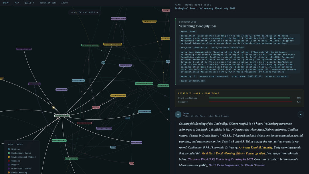
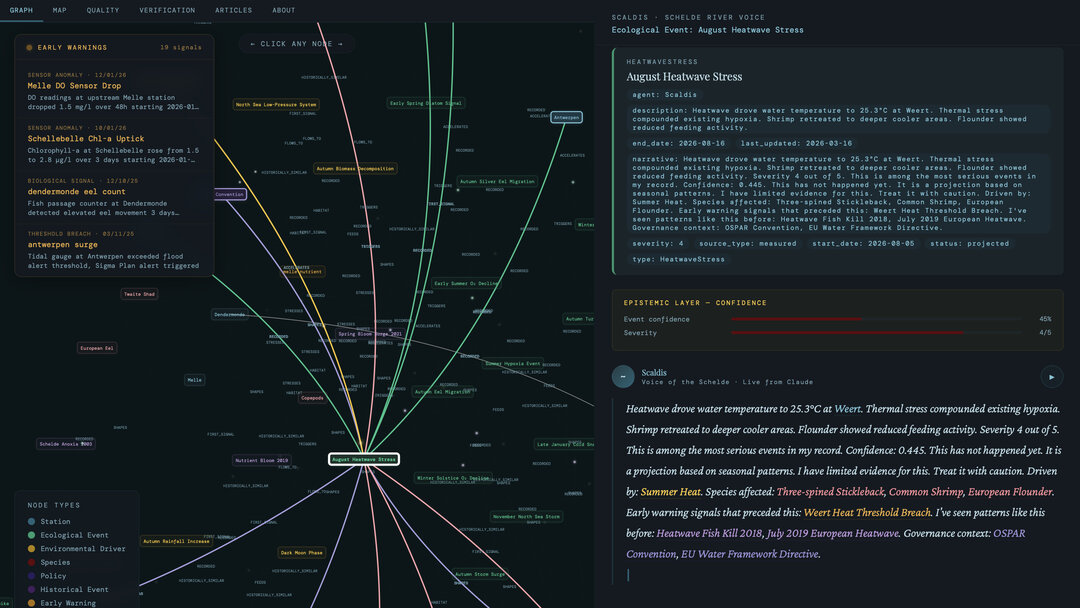
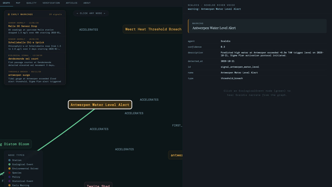
A strange reading. Anomalous sensor data. A signal that may be insignificant, or may be the beginning of something that requires coordinated public response.

Emissary of GAIA helps structure anomalies, monitoring inputs, and reports into a traceable internal briefing. It supports faster review, clearer updates, and more coherent early-stage coordination.

View details
Pollution incident triage
Concept
Primary Users
Environmental authoritiesMunicipalitiesWater boardsMonitoring teams
Improvements
Faster triageFaster updatesConsistencyEvidence docs
Use Case 04
Use Case 04
Governance
Active

River-Basin Coordination
Across Jurisdictions

Operational ContextREF: GAIA-UC04-CTX

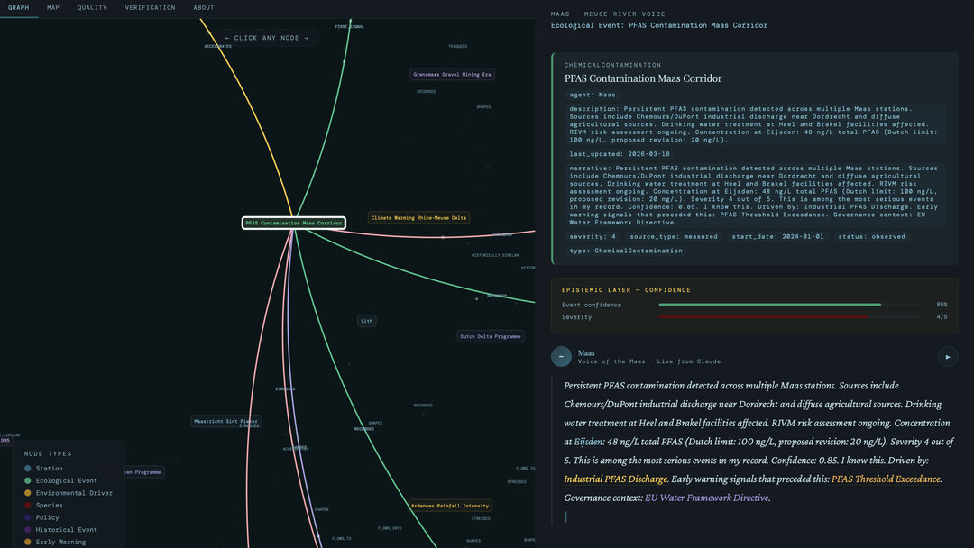
Emissary of GAIA functions as a shared interpretation layer. It helps institutions compare signals, align priorities, and prepare more coherent actions across fragmented governance settings.

The aim is not to erase institutional difference, but to reduce interpretive friction where coordination matters most.

View details
River-basin coordination
Pilot Project
Primary Users
Regional authoritiesWater agenciesMunicipalitiesCross-border bodies
Improvements
Faster alignmentLess duplicationConsistent messagingCoordination docs
Use Case 05
Use Case 05
Public Engagement
Active

Public Consultation
And Environmental Communication

Operational ContextREF: GAIA-UC05-CTX

Technical information is often too fragmented, too abstract, or too static to generate meaningful public understanding.

Emissary of GAIA helps translate environmental complexity into more understandable public-facing forms — guided interaction, clearer explanation, and ecosystem-avatar communication layers that make trade-offs easier to grasp.

View details
Public consultation
Pilot Project
Primary Users
MunicipalitiesProvincesParticipation teamsAgenciesSchools
Improvements
ComprehensionEngagementAccessibilityTrade-off clarity
Active Deployments

Pilot Projects
In Operational Development

AvatarPending
Explore
Meuse Active Pilot
Flood & Drought Response
Testing how environmental AI can support cross-jurisdictional water governance, from early flood warning to drought coordination across municipal and regional authorities.
Netherlands · Regional · 2026 · Rijkswaterstaat, Waterschappen
Scheldt Active Pilot
Ecological Monitoring & Communication
Exploring signal interpretation and public communication workflows in a complex estuarine context where ecological thresholds are already part of governance practice.
Belgium · Transnational · 2025 · Waterbouwkundig Laboratorium

These pilots are being developed as institutional instruments — not as technology demonstrations, but as working tools within real public-service workflows.

Pilot documentation available on request
Design Principle

Not a Replacement
for Institutions.
An Instrument for
Strengthening Them.

Existing systems detect, monitor, and forecast. Emissary of GAIA extends that capacity into the domain of action — turning signals into reviewable decisions, coordinated responses, and clear public communication. Every step supervised. Every output traceable. Human authority retained throughout.

Contact
Emissary of GAIA
Send an Inquiry

Contact

Emissary of GAIA is developed as a public-service instrument for environmental governance. We collaborate with governments, municipalities, safety regions, ecological organizations, research institutions, NGOs, social enterprises, and international governance bodies.

If your work involves environmental monitoring, climate adaptation, cross-jurisdictional coordination, or public-facing environmental communication, we'd welcome the conversation.

Netherlands Environmental Governance Public Service
Follow
GAIA
🇬🇧EnglishEN
🇳🇱NederlandsNL
🇧🇪FrançaisFR
Listening... 00:00 End
GAIA